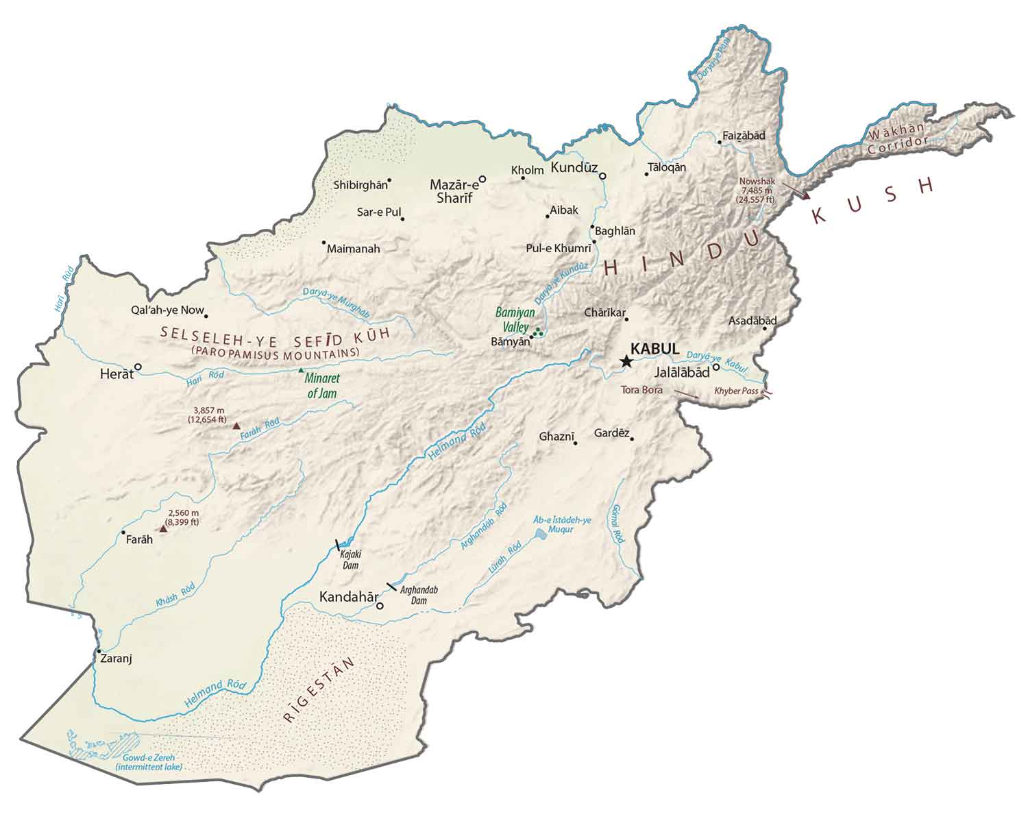
Afghanistan's physical map reveals a landlocked nation dominated by rugged mountains, vast plateaus, and significant river systems. This informational guide explores the diverse topography, from the towering peaks of the Hindu Kush to the arid plains and fertile river valleys. Understanding Afghanistan's physical geography is crucial for grasping its historical development, cultural diversity, and strategic importance. Key features include the Amu Darya river, the Helmand River, and various deserts like the Registan. Mobile users seeking insights into the nation's natural landscapes will find detailed information on its elevation changes, climate zones, and major geological formations, offering a comprehensive overview of its challenging yet captivating terrain. This overview aids in visualising the natural barriers and resources that have shaped Afghanistan over millennia, providing essential context for anyone exploring its geographical makeup.
- What is the highest point shown on a physical map of Afghanistan? - The highest point in Afghanistan is Mount Noshaq, part of the Hindu Kush range, located in the northeastern province of Badakhshan. It stands at an impressive 7,492 meters (24,580 feet) above sea level, making it a prominent feature on any detailed physical map of the country.
- How do the rivers on Afghanistan's physical map flow? - Rivers like the Amu Darya form the northern border, flowing westward into the Aral Sea. The Helmand River originates in the Hindu Kush and flows southwest, often ending in internal wetlands. Other rivers like the Hari Rud generally flow west, influencing regional agriculture and population centers.
- What types of terrain are visible on a physical map of Afghanistan? - Afghanistan's physical map displays a diverse terrain, primarily characterized by rugged mountain ranges (Hindu Kush), high plateaus, and extensive deserts (Registan, Dasht-e Margo). It also includes fertile river valleys in contrast to the arid landscapes, showcasing significant geographical variety.
- Where are the agricultural regions typically found on an Afghan physical map? - Agricultural regions on Afghanistan's physical map are typically concentrated along major river valleys, such as those of the Amu Darya, Helmand, Kabul, and Hari Rud. These areas benefit from water sources in an otherwise largely arid or mountainous country, supporting cultivation.
- Does Afghanistan's physical map reveal earthquake zones? - Yes, Afghanistan's physical map, especially when combined with geological data, reveals its location in an active seismic zone. The Hindu Kush region, where the Indian and Eurasian tectonic plates meet, is particularly prone to earthquakes, impacting the landscape and infrastructure.
- How does the physical map explain Afghanistan being landlocked? - The physical map clearly shows Afghanistan's lack of direct access to an ocean or sea, surrounded entirely by neighboring countries. This landlocked status significantly influences its trade routes, geopolitics, and reliance on overland connections through mountainous and desert terrains.
- What is the significance of the Hindu Kush on Afghanistan's physical map? - The Hindu Kush mountain range is geographically central to Afghanistan, profoundly shaping its climate, population distribution, and historical isolation of various regions. It acts as a major watershed and a natural barrier, significantly influencing the country's physical and cultural landscapes.
- What are the prominent mountain ranges on a physical map of Afghanistan?
The Hindu Kush is the most prominent, stretching across the central and northeastern parts of Afghanistan. Other significant ranges include the Paropamisus in the west and the Safed Koh along the eastern border.
- Which major rivers are visible on Afghanistan's physical map?
Key rivers include the Amu Darya, forming much of the northern border, and the Helmand River, the longest river entirely within Afghanistan, flowing through the arid southwest.
- Where are the major desert areas located on a physical map of Afghanistan?
The principal desert areas are found in the south and southwest, notably the Registan Desert and parts of the Dasht-e Margo. These are characterized by vast sand dunes and arid conditions.
- How does elevation vary across the physical map of Afghanistan?
Afghanistan's elevation varies dramatically, from low-lying deserts and plains in the southwest and north to towering peaks in the Hindu Kush, with many summits exceeding 6,000 meters. The average elevation is quite high.
- What are the main geographical regions on an Afghan physical map?
The main regions include the central highlands (dominated by the Hindu Kush), the northern plains, the southwestern plateau and deserts, and the eastern mountain ranges. Each has distinct physical characteristics.
- Does the physical map show significant bodies of water besides rivers?
While major lakes are fewer, the physical map depicts seasonal wetlands and some smaller permanent lakes, particularly in the southwest, often fed by rivers like the Helmand. The Band-e Amir lakes are notable.
- How does Afghanistan's physical geography influence its climate?
The high mountain ranges block moisture, creating arid and semi-arid conditions across much of the country. Elevation causes significant temperature variations, with cold winters in the mountains and hot summers in the plains.
Ever wondered about the rugged beauty of Afghanistan's natural landscape? A physical map of Afghanistan unveils a nation defined by its dramatic mountains, expansive deserts, and vital river systems. This guide dives deep into the geographical features that shape this resilient country, providing quick, scannable insights for anyone curious about its terrain. Let's explore the peaks, valleys, and waterways that tell Afghanistan's story.
Frequently Asked Questions
Where can I find detailed physical maps of Afghanistan?
For the absolute best locations, digital atlases like Google Earth and specialized cartographic sites such as National Geographic Maps offer high-resolution physical maps of Afghanistan, detailing its diverse topography.
How can Local MAPs help me understand Afghanistan's terrain?
Pull up your preferred mobile Maps app to verify real-time geological data. You can zoom into mountain ranges and river systems, offering an interactive and immediate understanding of the complex topography and elevation changes across Afghanistan.
What are the key physical features highlighted on Afghan maps?
Key features include the towering Hindu Kush mountain range, the significant Amu Darya and Helmand rivers, and vast arid regions like the Registan Desert. These define Afghanistan's diverse and challenging natural landscape.
Quick Local Guide: Key Geographical Features- Major Feature: Hindu Kush Mountains
Region/Significance: Central and Northeastern Afghanistan, defines much of the terrain. - Major Feature: Amu Darya River
Region/Significance: Northern border, vital water source. - Major Feature: Helmand River
Region/Significance: Southwest, longest river entirely within Afghanistan. - Major Feature: Registan Desert
Region/Significance: Southern Afghanistan, arid sandy plain.
All maps focus on physical map of afganistan.
Hindu Kush mountains, Amu Darya river, Helmand River, Registan Desert, central highlands, arid plains, fertile valleys, significant elevation changes, strategic landlocked position, diverse climate zones.


A Physical Map Of Afghanistan Detailed Physical Map Of Afghanistan . Highly Detailed Physical Map Of Afghanistan In Vector Format With All Download. Afghanistan Map 3D Relief Map Of Afghanistan . Detailed Physical Map Of Afghanistan Stock Vector Image Art Alamy Detailed Physical Map Of Afghanistan 3A93JMY . Blank Physical Map Of Afghanistan Printable Printables Templates Free Afghanistan Physical Map


Physical Map Of Afghanistan Ezilon Maps Detailed Relief Map Of Afghanistan . Afghanistan Geography Images At Edith Corlett Blog Physical Map Of Afghanistan 1 Large . Afghanistan Geography Map Large Physical Map Of Afghanistan . A 3D Rendering Of The Physical Map Of Afghanistan Isolated On A White A 3d Rendering Of The Physical Map Of Afghanistan Isolated On A White Background 2KA46C0 . A Physical Map Of Afghanistan Highly Detailed Afghanistan Physical Map 2PGDKCH


Physical Map Of Afganistan Afghanistan Map Physical . 108 026 Afghanistan Royalty Free Images Stock Photos Pictures Highly Detailed Afghanistan Physical Map 260nw 2031113858 . Premium Photo Blank Physical Topographic Map Of Afghanistan Blank Physical Topographic Map Afghanistan 509477 2174 . Afghanistan 2026 Complete Guide To Geography History Climate Location Of. Map Of Afghanistan Showing Elevation River Lines Map Of Afghanistan Compiled By Malyarove And Digitized By Hamidi And Q640


Afghanistan Map Cities And Roads GIS Geography Afghanistan Physical Map . Afghanistan Physical Geography M RedRoads . Afghanistan Maps Facts World Atlas Af 01 . Large Detailed Map Of Afghanistan 2008 Afghanistan Large Detailed Map Of Afghanistan 2008 . Liberation Day 2025 And 2026 In Afghanistan BVMEM


Physical Map Of Afghanistan Political Map Of Afghanista . Afghanistan Map Afghanistan Afghanistan Map . US Army Map Of Afghanistan Us Army Map Of Afghanistan . Afghanistan Doc S Books Afghanistan Map Explainer 1 . Maps Of Afghanistan Detailed Map Of Afghanistan In English Military Large Map Of Afghanistan


Afghanistan Acute Situation For June September 2025 And Afghanistan AMN Projection Nov 2025V2 . Afghanistan Maps Maps Of Afghanistan Map Of Afghanistan . Maps Of Afghanistan Political Map Afghanistan Scaled . Afghanistan Crisis Response Plan 2026 IOM Afghanistan Operational Map . Afghanistan Location 755


Afghanistan Terrain Map Vintage Afghanistan Map 1969 Black Frame . Physical Map Of Afghanistan By Maps On The Web . Afghanistan Map Mapping The Advance Of The Taliban In Afghanistan Afghanistan Highly Detailed 3d Rendering Of Shaded Relief Map With Rivers And Lakes Colored By Elevation Created With Satellite Data 2NE3A0A . Detailed Political Map Afghanistan Stock Vector Royalty Free Stock Vector Detailed Political Map Of Afghanistan 2604952761 . Afghanistan Physical Features Map Afganistan Physical 1 1024x725